Home » Planning Topics » Environment » Climate Action Planning » Measuring Progress » Agriculture, Food, and Forestry
Agriculture, Food, and Forestry
2023 METRICS
METRIC 16
Protected open space
Percent increase in protected open space, which includes agricultural land, natural areas, public parks, state game lands, open space owned by homeowners' associations, and other permanently protected lands.
Open space maintained as healthy farmland and well-managed grasslands and woodlands store and sequester carbon, offsetting greenhouse gas emissions elsewhere.
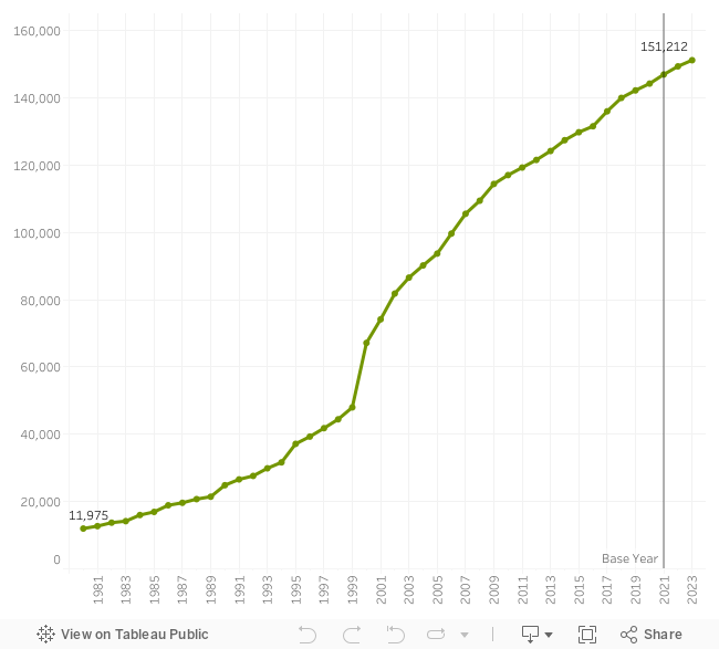
Protected open space (acres)
This metric coordinates with Landscape3 metric 1.
Data Source: Chester County Planning Commission Protected Open Space Tracking (POST).
1.6%
Increase in protected open space
SINCE BASE YEAR 2021
Steady Progress
The county's continued commitment to supporting open space preservation has resulted in a steady increase in preserved land. Currently 31.1% of the county's land area is preserved.
METRIC 17
Protected Farmland
Percent increase in protected farmland.
Thoughtfully stewarded agricultural soils have significant capacity for carbon storage. Maintaining land as farmland rather than developing it maintains the opportunity for this carbon storage.
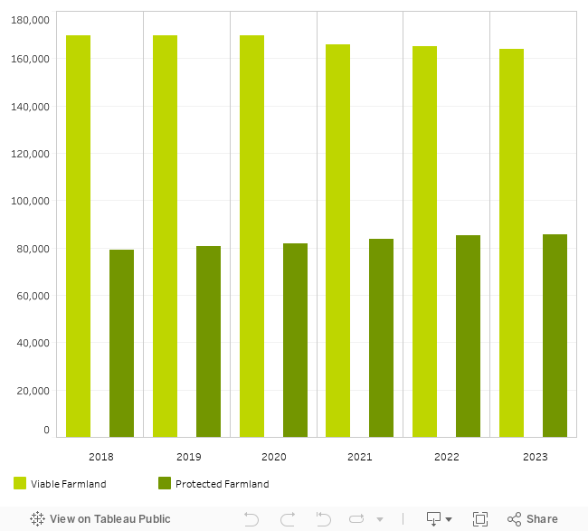
Protected farmland (acres)
This metric coordinates with Landscape3 metric 3.
Data Source: Chester County Planning Commission Protected Open Space Tracking (POST).
2.3%
Increase in protected farmland
SINCE BASE YEAR 2021
Keeping pace
Farmland protection is keeping pace with farmland lost to development.
METRIC 18
Protected woodlands
Percent increase in protected woodlands.
Woodlands are important for storing and sequestering carbon dioxide, a greenhouse gas. Growing trees take in atmospheric carbon, sequestering it in their new growth. Trees in climax forests store carbon in their biomass, and return much of it to the soil when they die and decay.
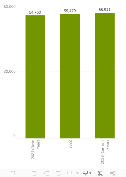
Tree cover (acres) within protected land (excluding agricultural conservation easements preserved through the ALPB)
Data Source: Chester County Planning Commission Protected Open Space Tracking (POST).
2.1%
Increase in protected woodands
SINCE BASE YEAR 2021
Steady Progress
Prioritizing woodland protection has protected 1,151 acres of woodlands since 2021, which amounts to 27% of the total land area that was preserved over that time.
METRIC 19
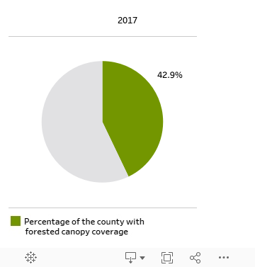
Tree cover
Net change in tree canopy coverage county-wide.
Growing trees sequester carbon in their new growth. This growth, as well as new tree plantings, are captured in this metric.
Tree cover
Data source: Chesapeake Conservancy Land Cover (updated every 5 years)
Updated data needed
The landcover data used in this metric is updated every 5 years. Updated data is expected in 2024.